GMA 10 Joint Planning
Next GMA 10 Meeting TBD
GMA 10 Joint Planning Meetings & Materials
| Meeting Agenda | Meeting Materials | Meeting Minutes |
| Oct 26, 2021 Meeting Agenda | Will Be approved at the Next GMA 10 Meeting TBD | |
| August 10, 2021 Meeting Agenda | August 10, 2021 Meeting Minutes | |
| April 20, 2021 Meeting Agenda | April 20, 2021 Meeting Minutes | |
| March 9, 2021 Meeting Agenda |
|
March 9 2021 Approved Minutes |
| January 26, 2021 Meeting Agenda | 1/26/2021 | |
| December 8, 2020 Meeting Agenda |
|
December 8, 2020 Approved Meeting Minutes |
GMA 10 3rd Round of Planning Information
- GMA 10 Public Comment Form
- GMA 10 Resolution Proposing 2021 DFCs Final
- DFC and Non Relevant Aquifers letter to GMA 10 GCDs 4-23-21
Explanatory Report & Other Reference Documents
Below are the GMA 10 DFC Explanatory Reports from the last cycle which ended in 2017.
- Austin Buda Limestone Explanatory Report
- Leona Gravels Explanatory Report
- Northern Fresh Edwards Explanatory Report
- Saline Edwards Explanatory Report
- Trinity Explanatory Report
- Western Fresh Edwards Explanatory Report
Below are the documents for extra information and the DFC submission requirements and flow chart
- GMA 10 Current DFCs
- DFC Flow Chart
- DFC Submission Checklist
- TWDB GAM Run 16-033 MAG
- Task13-033 TERS
- 2016 GMA 10 MAG Table
- 2016 Texas Aquifers Study
- TWDB Subsidence Vulnerability Report
Helpful Links:
- TWDB 2017 State Water Plan Interactive Dashboard
- Desired Future Conditions Information, TWDB
- Groundwater Management Area 9 Information, TWDB
- Groundwater Management Area 10 Information, TWDB
History of the Desired Future Condition (DFC)
In 2005, the Texas Legislature passed House Bill (HB) 1763 implementing an unprecedented joint groundwater planning process. The new process was intended to require coordinated planning of the shared aquifer systems in the State. HB 1763 requires that Groundwater Conservation Districts (GCDs) with common area in a particular Groundwater Management Area (GMA) collectively make policy decisions that determine the volume of groundwater pumpage available for permitting. These policy decisions are updated every 5 years or can be updated within a 5-year period.
What Is A DFC?
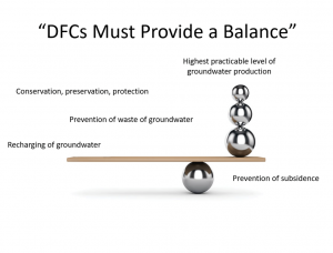
A DFC is defined as “the desired, quantified condition of groundwater resources (such as water levels, spring flows, or volumes) within a management area at one or more specified future times as defined by participating groundwater conservation districts within a groundwater management area as part of the joint planning process (TAC Title 31, Part 10, §356.10(6)).” As the term suggest, a DFC is a quantified management goal that captures the philosophy and policies addressing how an aquifer will be managed. These management goals help GCDs find a balance between sustainability and productivity for the future of the aquifer.
DFC Process Regionally
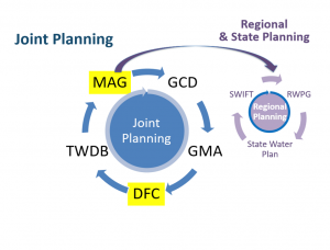
The DFC process first starts with each GCD regionally planning, through the GMAs, the next set od DFCs. GMAs will hold discussions on whether or not the DFC currently in place is adequate for the next 5 year cycle or if the DFC needs to change. Once the GMAs decide on a DFC for each aquifer within the GMA boundary, the proposed DFCs will be submitted to the Texas Water Development Board (TWDB). Once the TWDB deems the DFCs to be adequate, TWDB will then issue Modeled Available Groundwater (MAGs) estimates to each GCD. These MAGs will then be used in Regional Water Planning Groups (RWPGs), the State Water Plan, or for gaining grants through the State Water Implementation Fund for Texas (SWIFT).
DFC Process On The Local Level
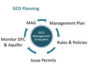
Once the TWDB issues the MAGs. Each GCD will then take the MAGs and update their Management Plan accordingly. Once TWDB approves the Districts Management Plan, the District has 2 years to update and change rules so that the District can achieve its Management Plan. The way that GCDs monitor the DFCs and whether or not the GCD is achieving said DFCs is through permitting, aquifer science and MAG consideration.
BSEACD and the DFC Process
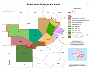
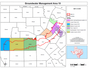
Currently, BSEACD is in its 3rd round of DFC planning. BSEACD is currently involved in 2 GMAs, GMA 9 and GMA 10.
BSEACD currently has a Trinity DFC of a regional water level drawdown not exceeding 25 feet during average recharge conditions. The District has established 3 management zones for the Trinity aquifer, the Upper, Middle and Lower and is proposing to revise the DFC expressions for those zones. The proposed DFC expression would be revised to read “Annual average drawdown among DFC-designated Middle Trinity monitor wells is not to exceed 25 feet within the BSEACD from the regional average water level surface over the next 50 years.” The Lower Trinity DFC expression would be revised to read “Average drawdown among DFC-designated monitor wells is not to exceed 25 feet within BSEACD from the reference water level over the next 50 years.”
BSEACD feels that the DFC process is critical to groundwater management for the future of water supplies. The reason that BSEACD is proposing these expression revisions is due to BSEACD feeling that the current DFC is too vague and open for interpretation. Below are a few reasons why the District is proposing these DFC expression revisions:
- Regional Extent of Expression
- Vertically Undifferentiated Trinity
- Sparse Monitor Wells and Data
- No Reference Point Defined for Drawdown
- No Defined or Accepted Method for Monitoring the DFC
