Drought Information & Resources
Useful Drought Links
- BSEACD Drought Status
- BSEACD Drought Management
- BSEACD Drought FAQ
- United States Geological Survey (USGS) Drought Watch
- Lower Colorado River Authority (LCRA) Hydromet
- Texas Water Development Board (TWDB) Water Data Dashboard
- Hays Trinity Groundwater Conservation District | Water Level Monitoring
District Enters Stage III Critical Drought
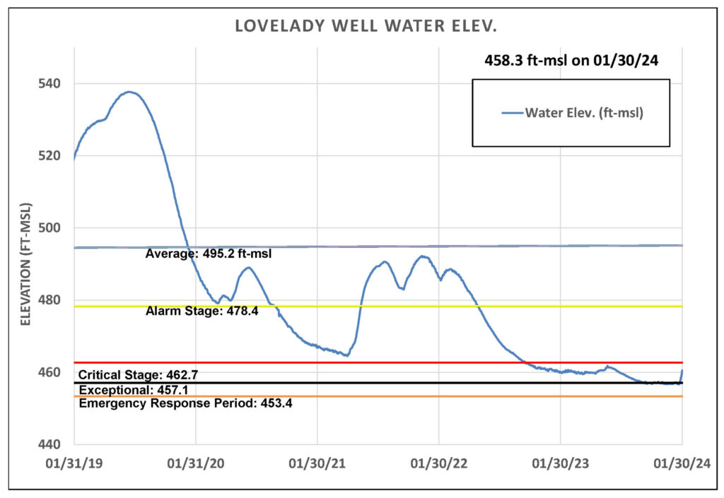
On February 8, Barton Springs/Edwards Aquifer Conservation District declared Stage III Critical Drought- a move up from Stage IV Exceptional Drought. This transition is a result of the Lovelady monitor well, one of two drought trigger determinants, reaching a 10-day average above 457.1 feet-mean sea level (ft-msl). Barton Springs flow has a 10-day average of 70 cfs, which is above the Stage I: No Drought Stage. Only one of the District’s two drought monitor sites (Lovelady monitor well and Barton Springs) needs drop down into a new drought threshold for a declaration to be made. However, to exit a drought stage both Barton Springs and Lovelady must rise above their respective drought trigger values.
|
Barton Springs Discharge (cubic feet per second) Previous: 70 cfs on 2/6/24 |
Drought Status |
Lovelady Monitor Well Water Elevation (msl) Previous: 462 msl on 2/6/24 |
Water Conservation Period
(In May-Sept it’s Stage I
if in No Drought)
Alarm Drought
Critical Drought
Exceptional Drought
| Lovelady Monitor Well Water Elevation | |
| Drought Status | (msl) |
msl
Water Conservation Period
(In May-Sept it’s Stage I
if in No Drought)
Alarm Drought
Critical Drought
Exceptional Drought
The chart above displays the current stage of drought based on values from Barton Springs and Lovelady monitor well, the District’s two drought monitor sites. You can view Barton Springs flow data and Lovelady monitor well water level values below for additional information.
Pumpage Reductions
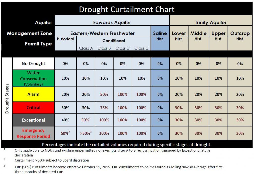
Declaration of Stage III Drought requires all District permittees to implement mandatory measures specified in their User Drought Contingency Plans (UDCPs) to meet monthly pumpage reduction requirements. Based on classification, pumpage restrictions are as follows:
- 30% for Edwards Historical and Conditional Class A permittees
- 75% for Edwards Conditional Class B permittees
- 100% for Edwards Conditional Class C and Class D permittees
- 30% for Trinity and Alluvial/Austin Chalk Historical permittees
End-user customers served by water utilities on groundwater wells are required to comply with their utility’s water use restrictions for this drought stage. Generally, outdoor irrigation of lawns and landscaping is now prohibited or severely restricted. Groundwater uses should be limited for essential indoor demands needed to preserve health and safety with a very minor allocation provided for non-essential outdoor water use. Permittees should refer to the monthly drought allocations listed in their User Drought Conservation Plan (UDCP) and Drought Target Charts.
The following are currently prohibited by District permittees.
- Automatic irrigation systems
- Hose end sprinklers
- No car washing
- No filling or re-filling of pools
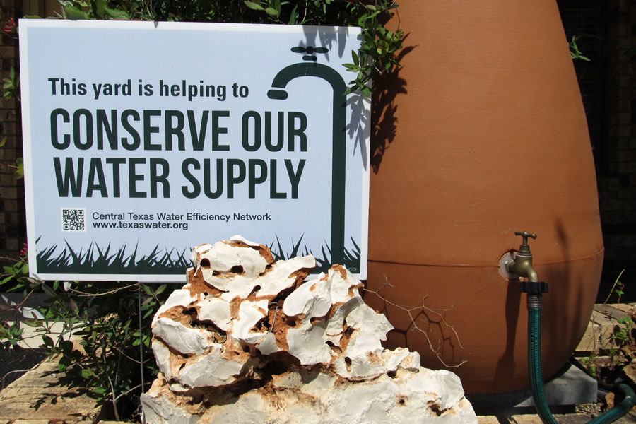
Planting native or drought-tolerant landscapes, mulching, and using compost can substantially reduce the amount of irrigation water required to keep plants healthy. Make sure your irrigation system is functioning at peak efficiency and replace leaking gaskets and hoses to conserve water. Installing a rain barrel or rainwater harvesting system can make an even bigger impact in reducing overall water use. You can also replace fixtures in your home with WaterSense labelled ones and and use at least 20% less on water.
The District recommends that both exempt and permitted well owners follow these conservation tips. For additional information on groundwater wells, please take a look at the District’s Well Owner Guide. If you have questions about your well, please contact us at 512-282-8441. We encourage you to call or visit our office during office hours (8 a.m. to 5 p.m.) to review our groundwater management process, receive information about the drought, or get assistance with other groundwater related matters.
District Drought Status Chart
The District’s drought trigger methodology below includes curtailments for each stage of drought. Our drought management web page has additional information.
Drought-Relevant Graphs
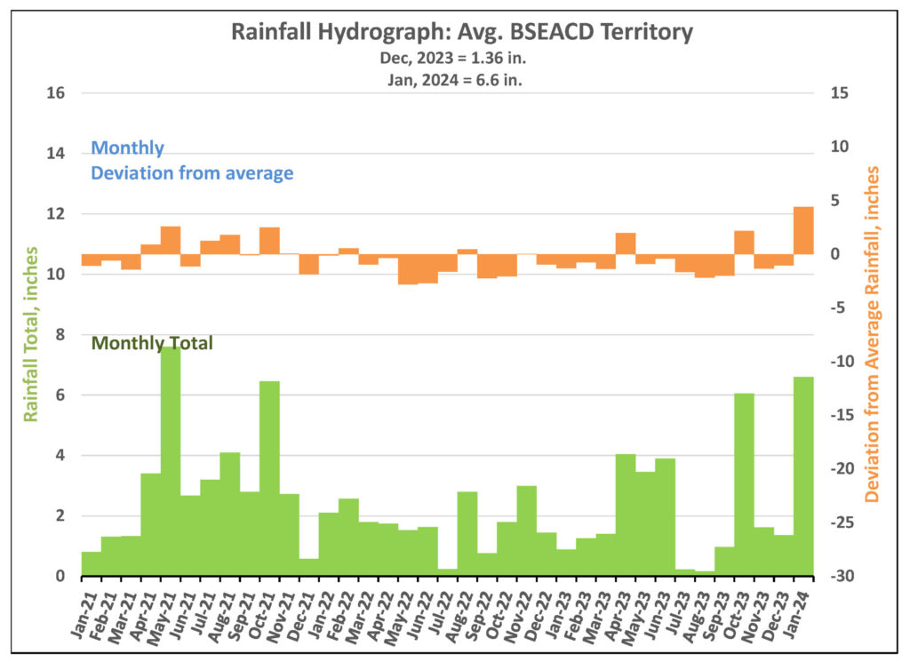
Rainfall Hydrograph
Here you can see the monthly average rainfall for the district and monthly deviations from the average
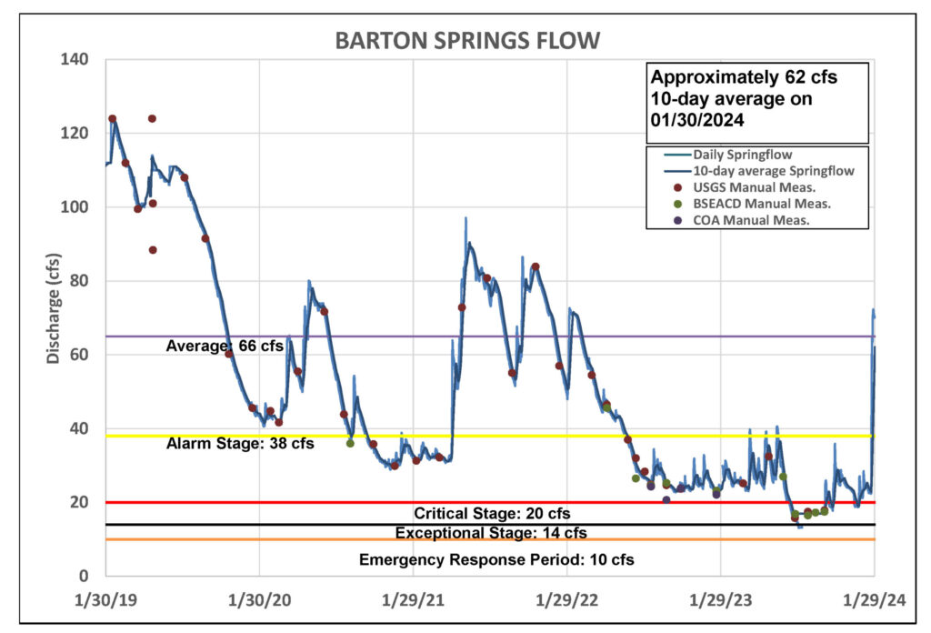
Barton Springs Segment of the Edwards Aquifer Conditions
Below are graphs showing data from the two drought determinants of the District: Barton Springs flow and Lovelady monitor well groundwater level.
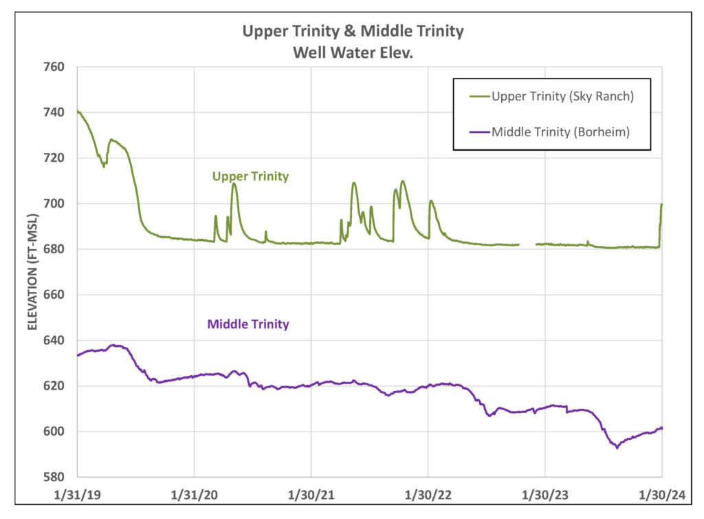
Here you can see the water levels of the wells in the Upper and Middle Trinity aquifers.
Press Coverage
- District foresees unprecedented transition to Stage IV Exceptional Drought – BSEACD
- Aquifer district expecting unprecedented drought declaration – Austin Monitor
- Barton Springs flow is low, officials preparing for next level of drought – KXAN
- Barton Springs Segment of the Edwards Aquifer approaching historical low – KXAN
- Barton Springs/Edwards Aquifer Conservation District foresees transitioning to Stage IV drought – The Hays Free Press
- What impact is Texas drought having on Austin-area swimming holes? Here’s what experts say – Austin-American Statesman
- Dry Springs in Central Texas Warn of Water Shortage Ahead – Inside Climate News
