About the Aquifers
Overview
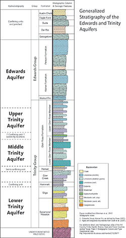 The groundwater within Barton Springs/Edwards Aquifer Conservation District’s jurisdictional boundaries serves as vital resources for municipal, industrial, domestic, recreational, and ecological needs. The District includes three main aquifers:
- The Barton Springs segment of the Edwards Aquifer
- The Saline (Brackish) Edwards Aquifer
- Trinity Aquifer
Approximately 50,000 to 60,000 people depend upon water from the Barton Springs segment of the Edwards Aquifer. Additionally, Barton Springs is the only known habitat for the endangered Barton Springs salamander.
The District has about 1,230 operational wells with about 100 permit-holders totaling about 2.2 billion gallons (6,600 acre-ft/) of annual permitted pumping (without drought reductions) in fiscal year 2008.
Aquifer units within the BSEACD range in age from Cretaceous (ca. 100 Mya) to Holocene (10,000 years ago) and consist of limestone, gravel, sand, and clay. The most prolific aquifers within the study area are composed of Cretaceous-age limestone and sand units that comprise the Edwards and to a lesser extent the Trinity Aquifers.
The Balcones Fault Zone (BFZ), a series of northeast-trending faulting strongly influences groundwater flow in central Texas.
Barton Springs Segment of the Edwards Aquifer
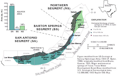
The Edwards Aquifer of Central Texas is subdivided into the Northern, Barton Springs, and San Antonio segments. The Edwards Aquifer is composed of the Cretaceous-age Edwards Group (Kainer and Person Formations) and the Georgetown Formation in Central Texas.
The Barton Springs Aquifer covers about 155 mi2 and is composed of limestone that is highly faulted, fractured, and dissolved, forming a very prolific karst aquifer ranging from 0 to 450 feet thick. The Barton Springs Aquifer provides the majority of groundwater within the BSEACD. The segment is divided into essentially four hydro zones: contributing, recharge, confined, and saline zones.
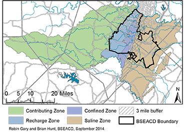
Generally, rainfall collects and runs off land in the contributing zone and fills creeks that cross into the recharge zone. Recharge refers to water replenishing the aquifer. The recharge zone is where the exceptionally porous Edwards limestone is exposed at the surface providing direct access to the groundwater system. Recharge occurs mainly along the six major streams that cross the recharge zone, but also in upland areas of the recharge zone. In creek beds and in upland areas, there are very thin to no soils to help remove contaminants before they enter the groundwater system. The benefit is that water can replenish the water supply, but the drawback is that the quality of that water is directly linked to land use and surface water quality. Conservation easements, building restrictions, impervious cover limitations, high stormwater treatment standards, and most importantly, residents’ land stewardship have been effective at protecting the quality of water recharging the aquifer, so far. With increasing development, the quality of the water in the freshwater Edwards is at greater risk of contamination.
Water levels in the freshwater Edwards Aquifer vary according to the amount of water stored in the aquifer, which is dependent upon the climatic conditions. In addition, the location (Western Edwards–unconfined or Eastern Edwards–confined zones) within the aquifer can also influence the water levels and how much they may vary over time. Barton Springs and some wells respond very quickly to recharge events reflecting their influenced by conduit (fast) permeability. Most water wells show a combined influence of matrix (slow) and conduit flow. Wells in the freshwater Edwards are subject to significant drought restrictions.
The saline zone of the Edwards is located in the eastern section of the District. Generally, water is more stagnant, and therefore, has a high concentration of total dissolved solids–making it brackish. Water must be treated, but there are few wells, relatively large available volume of water, and few drought restrictions for water pumped from the saline zone. This area is the focus of many water availability and treatment studies at the local and state level. Any permitted wells in this zone must not influence the fresh/saline water boundary.
Trinity Aquifer
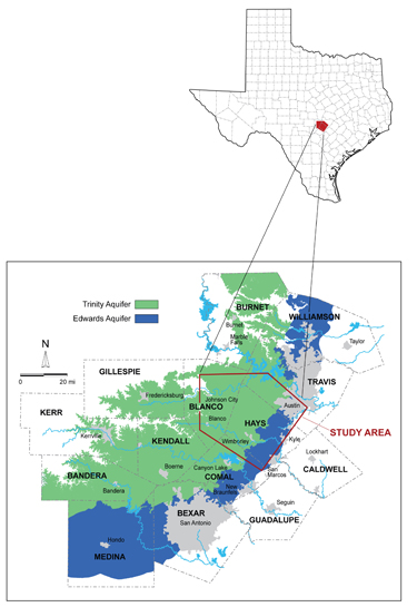
The Edwards Aquifer overlies the Trinity Aquifer system in the BFZ but is exposed at the surface in the Hill Country. The Trinity Aquifer is composed of the Trinity Group geologic units. The aquifer is divided into three hydrostratigraphic units, the Upper, Middle, and Lower Trinity. The occurrence of groundwater in these carbonate aquifers is primarily in fractures, along bedding planes and in karst features. Relatively abundant quantities of groundwater occur in skeletal and rudist reef facies.
Along the western part of the Edwards Aquifer where it’s thin, water-supply wells commonly penetrate the lower Edwards units and are completed in the Upper Trinity Aquifer. The Upper Trinity Aquifer comprises the Upper Glen Rose Formation, which satisfies, almost exclusively, domestic and livestock needs with very small (less than 5 gpm) to small (5–20 gpm) yields of highly mineralized water (relative to the Edwards Aquifer) in the Central Texas Hill Country west of the BFZ (DeCook, 1960; Ashworth, 1983; Muller and McCoy, 1987). The Upper Trinity Aquifer, consistently about 350 to 400 ft thick in Hays County, has hydraulic properties (storage and hydraulic conductivity) substantially lower than those of the Edwards Aquifer (Ashworth, 1983; Barker et al., 1994). Seasonal variations in heads in the Upper Trinity Aquifer are most dramatic in wells less than 250 ft deep. These aspects make the Upper Trinity Aquifer more susceptible than the Edwards Aquifer to the effects of drought (Barker et al., 1994).
The Middle Trinity Aquifer, consisting of the Lower Glen Rose, Hensel, and Cow Creek formations, underlies the Upper Trinity Aquifer. The Middle Trinity Aquifer is the primary aquifer in the Hill Country for residential and public water supply wells. Where the Lower Glen Rose is exposed at the surface, particularly in the Woodcreek area along Dry Cypress Creek and the Blanco River watershed west of Wimberley, the Lower Glen Rose is faulted, fractured and contains surficial karst features which allow for rapid and significant recharge of precipitation runoff.
The Hammett Shale is a confining layer, separating the Middle Trinity Aquifer from the confined Lower Trinity Aquifer. The Lower Trinity Aquifer consists of the Sligo and Hosston formations. The geologic units that make up the Lower Trinity Aquifer do not crop out in the study area except for a limited outcrop of the Sycamore/Hosston along the Pedernales River. On a regional basis, there is minimal recharge from precipitation on a surface outcrop because very little of this aquifer crops out in the study area. The primary recharge pathway to the Lower Trinity is by leakage from overlying and underlying aquifers (Ashworth et al., 2001). Because of lowering water levels in the Middle Trinity due to increased pumpage due to population growth, the Lower Trinity Aquifer is becoming an increasingly important source of water.
For detailed information on the Trinity Aquifer, please refer to Hydrogeologic Atlas of the Texas Hill Country.
