Drought Update 11.2.23
Record Heat to Record Cold
September seamlessly extended the scorching and arid conditions that characterized this summer. The persistent heat dome, an area of elevated upper-level high pressure, maintained its grip on our region for most of the month, resulting in temperatures higher than usual. In 2023, there were a staggering 80 days when the high at Camp Mabry made it to 100 degrees or more. It goes down on record as the second-highest number of triple-digit highs in a year, falling short of 2011’s record of 90.
October marked the one-year anniversary of the District entering Stage III Critical Drought and brought a wide array of weather along with it. From setting a record high on October 4 to the lowest recorded high temperature, 46 degrees, on October 30, we’ve seen it all this month. Thankfully, it also brought much needed precipitation throughout the District and Central Texas as a whole.
Rainfall
On average, September typically sees 3.45 inches of rainfall, making it the fourth wettest month of the year. However, this year’s meager total of 0.97 inches only amounted to a mere 28 percent of the usual September rainfall.
Conversely, October, typically the second wettest month (average rainfall is 3.9 inches), provided an average of 6 inches across the District (Figure 1). Specifically, Camp Mabry to ABIA region received around 6.2 inches, Buda to Wimberley recorded an average of 5.8 inches, and San Marcos received about 7.4 inches. Some waterways, like Onion and Barton creeks along with the Blanco River, experienced some elevated flow. Meanwhile, monitor wells in the Edwards and Trinity aquifers showed positive responses, indicating some much-needed groundwater recharge.
While this widespread, steady rain was helpful for groundwater resources, the Texas Hill Country remains in severe drought. Given that the District has experienced a rainfall deficit of 20 inches below the average in the past 24 months, a substantial increase in rainfall will be required to alleviate current drought conditions.
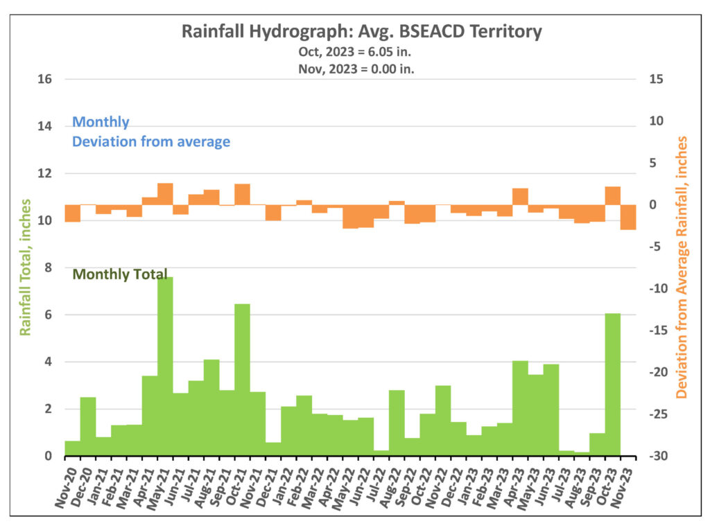
Figure 1. Monthly deviation from average and monthly total rainfall in BSEACD territory.
Barton Springs Discharge
The most recent manual measurement of Barton Springs flow reported 17.5 cubic feet per second (cfs) on October 2 (Figure 2). Barton Springs discharge has seen an increase due to the more than 4 inches of rain received in late October. According to the USGS gauge, the 10-day average flow as of November 2 is recorded at 29 cfs. The next manual measurement will be made in early to mid-November.
For the latest manual flow measurement data and drought information, please visit www.bseacd.org/regulatory/droughtinformation.
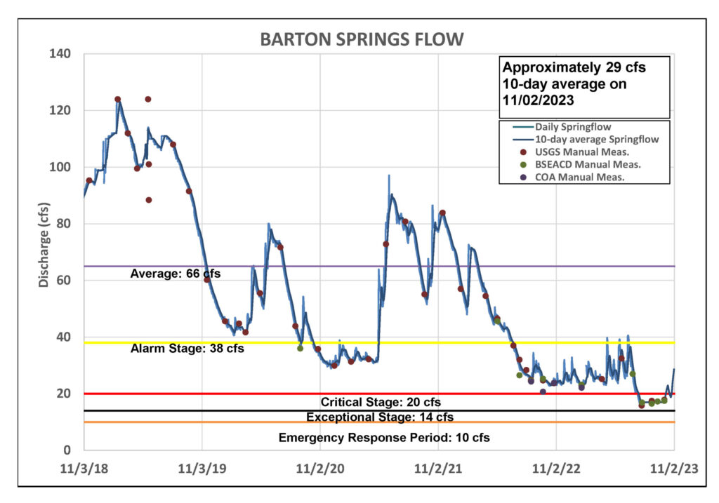
Figure 2. Barton Springs flow for the last five years.
Lovelady Monitor Well Groundwater Level
As of November 2, 2023, the Lovelady well recorded a 10-day average water level of 457.0 feet above mean sea level (ft-msl) (Figure 3). Despite being 0.1 feet below the Stage IV Exceptional Drought threshold, the recent substantial rainfall, averaging around 6 inches, is anticipated to raise the water levels at Lovelady back above the Stage IV threshold.
Water levels in the Lovelady monitor well are less influenced by rapid conduit flow and more reflective of diffuse flow and aquifer storage conditions. Consequently, Lovelady water levels show a delayed response to rainfall, taking up to two weeks to respond to a given rainfall event. The District is anticipating an increase in Lovelady levels in the coming days. We will continue to closely monitor Lovelady levels, as well as other climatic and hydrogeologic factors, when evaluating drought stage declarations.
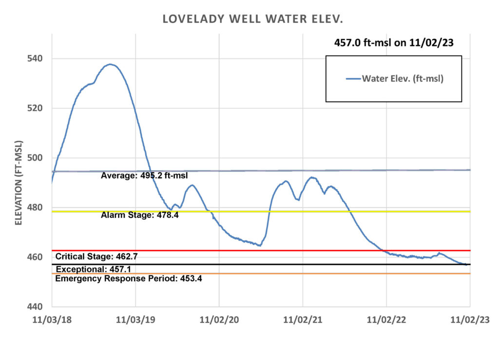
Figure 3. Lovelady monitor well water level elevation over the last five years.
Upper and Middle Trinity
In response to October rainfall, water levels in the Upper Trinity Aquifer (green) have shown a minor increase, while the Middle Trinity (purple) has shown a favorable response (Figure 4). The flow gauge at Jacob’s Well spring has reported a short-lived increase of flow to 2 cfs, and the Blanco River at Wimberley experienced a substantial surge in flow after this month’s rains
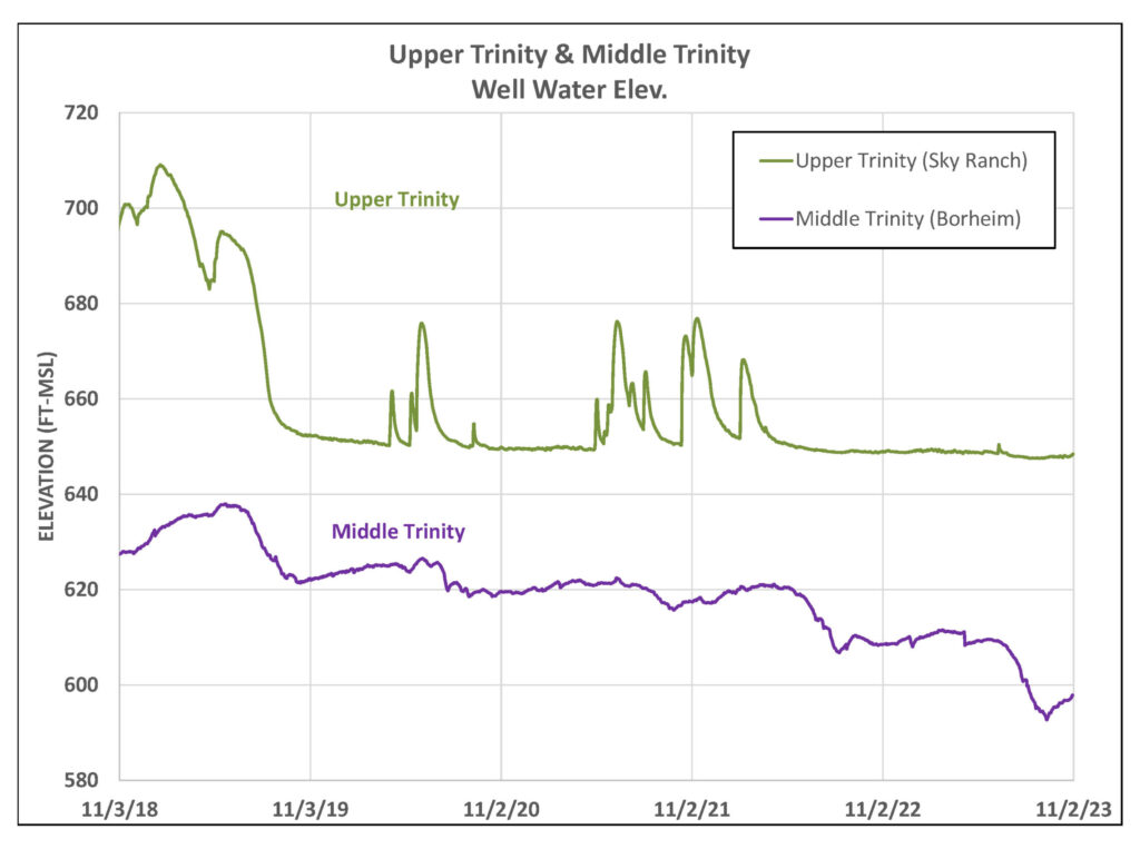
Figure 4. Water levels in an Upper Trinity well (green) and Middle Trinity well (purple) over the last five years.
Predictions and Conservation
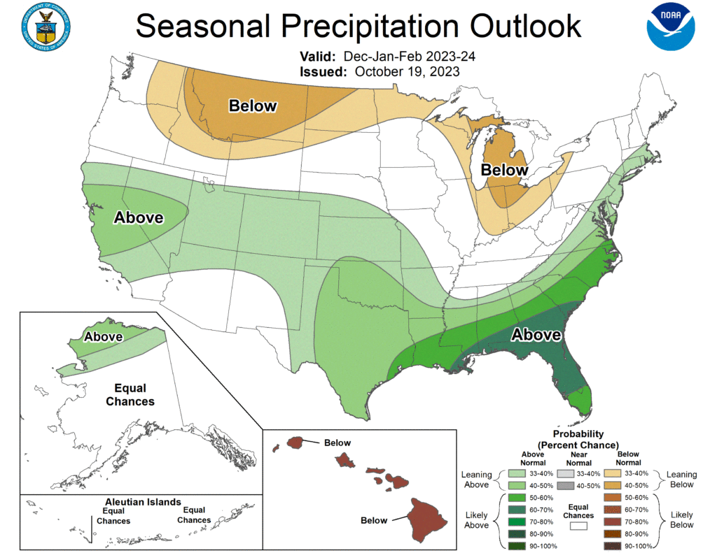
Meteorological winter begins December 1 and continues through the end of February, and NOAA predicts a wetter-than-normal season for Central Texas and most of the southern United States. While we’re expecting drought improvement this winter in the Texas Hill Country, it isn’t anticipated to be enough precipitation to get us completely out of drought.
Even with the heat of the summer behind us, it’s important for community throughout the District to continue to actively conserve groundwater resources. Planting native plants, replacing old, inefficient appliances, and repairing leaks are just a few ways to reduce your water consumption. You can also find additional ideas here.
